MyWachsWater puts your GIS data to work for you in ways you never imagined.
Designed exclusively for the iPad, this customizable tool puts the power of GIS data at your fingertips in the field, helping you make more informed decisions, saving your operation time and money.
Ideal for water and wastewater agencies, utilities, and local governments, GeoViewer Mobile provides convenient access – online or offline - to key information at the right time.
It streamlines workflow by:
•Adapting to location and offering context-sensitive actions and information
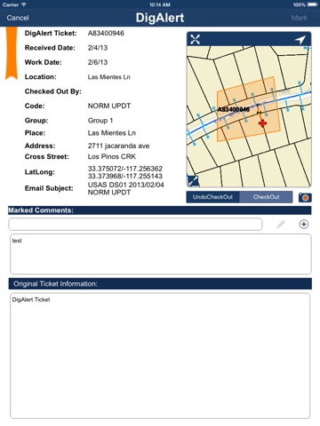
•Making work orders, DigAlerts, data collection, and preventive maintenance simpler and faster
•Providing a digital record of work performed
•Linking/updating seamlessly with online GIS data
Functionality:
•View water and wastewater distribution network and basemaps online or offline
•Use basemaps such as ESRIs Streets / Aerials / Topography as well as your own custom aerials
•View individual or multiple layers
•Search with flexible options including: hydrant number, valve number, APN, owner name, etc.
•Access and view documents such as as-built drawings, even when not connected to a network
•Add field notes with location metadata, attach photos and images with ability to add redlines
•Share map snapshots with colleagues and supervisors for timely action
•Bookmark areas of interest
•Take photos and videos to include in notes linked to a lot, hydrant, valve, etc.
•Manage work orders from your work order or service order management systems, even without network connectivity
•Provides a streamlined process to access and manage USA DigAlert tickets
•Easy to use preventive maintenance workflows with access to historical data
•Capture data from your valve turning machines right in the field to perform useful analysis and monitoring
•Provide an easy to use workflow to report leaks from the field
•Seamlessly integrates to the GeoViewer Online application enabling access to field data for supervisors and personal working from the office


